M+J=TrueLove: Marriott Motel Directions
Accommodations Directions & Weather Guest Book Registries Photos Area Attractions

Directions

To Tuscaloosa Via Air
click for interactive map

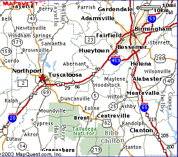
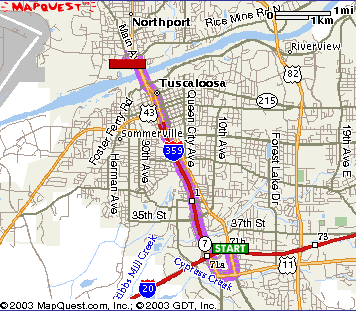
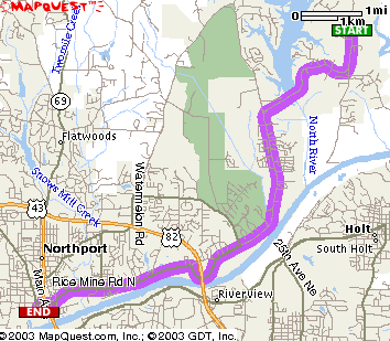
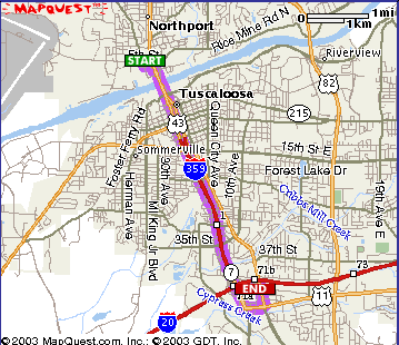
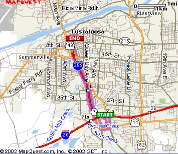
Birmingham (BHM) is the closest airport--an easy, 50-mile, 1-hour drive to Tuscaloosa, southwest on I59/20. Unfortunately, airport shuttles barely exist; but we hope to arrange our own informal shuttles.

Be sure to let us know when your flights arrive/depart.

Click image or here for additional maps.

Detailed driving directions to the Marriott Courtyard & Fairfield Inn.

To the UU Church from the Motels Total Estimated Time: 18 mins.
Total Distance: 11.13 miles
Part One

Part Two
  1. Work your way along the frontage road to US11/SKYLAND BLVD.
  2. Turn RIGHT on US11/SKYLAND BLVD.
  3. Merge RIGHT onto I359/US43, NORTH (towards Northport).
    2.82 miles.
  4. CONTINUE on I359 as it becomes a surface street: LURLEEN WALLACE BLVD. Go through downtown Tuscaloosa.
    1.09 miles.
  5. CROSS the BLACK WARRIOR RIVER.
  6. Take the NORTHPORT EXIT; go RIGHT at the bottom of the exit and onto RICE MINE RD.
  7. Bear RIGHT as you approach US82/MCFARLAND BLVD. Curve to the right and underneath MCFARLAND.
    6 miles.
  8. Turn RIGHT onto NEW WATERMELON RD.
    2.32 miles
  9. Church is on the LEFT.
To the Globe from the UU Church Total Estimated Time: 15 mins.
Total Distance: 8.35 miles
  1. Start out going Southwest on NEW WATERMELON RD--turning out of the parking lot to your RIGHT.
    2.23 miles.
  2. Soon after crossing the dam, turn LEFT onto RICE MINE RD at the T intersection. Continue to follow RICE MINE RD. as it curves under MCFARLAND BLVD. (US82). Be sure to bear LEFT after you curve under MCFARLAND and reach a traffic light.
    6.08 miles.
  3. Soon after you pass under LURLEEN WALLACE BLVD (US43) and RICE MINE RD. becomes 5TH STREET, turn LEFT onto MAIN AVE.
  4. The Globe is right on the corner of 5TH STREET (aka, Rice Mine Rd.) and MAIN AVE. Park anywhere downtown.
To the Motels from the Globe Total Estimated Time: 6 mins.
Total Distance: 4.93 miles
  1. From MAIN AVE. in downtown Northport, turn RIGHT onto 5TH ST. 0.06 miles
  2. Merge onto US-43 S/LURLEEN B WALLACE BLVD South. Cross the Black Warrior River.
  3. Go through downtown Tuscaloosa on LURLEEN WALLACE BLVD.
    1.09 miles.
  4. CONTINUE onto I359. 2.82 miles.
  5. After I359 ends (becoming US-69), turn LEFT on US-11/SKYLAND BLVD.
  6. Immediately turn left onto the frontage road and work your way to the motel.
To the Mellow Mushroom & Cobblestone Cafe from the Motels Total Estimated Time: 5 mins.
Total Distance: 4.18 miles
Part One
  1. Work your way along the frontage road to US11/SKYLAND BLVD.
  2. Turn RIGHT on US11/SKYLAND BLVD.
  3. Merge RIGHT onto I359/US43, NORTH (towards Northport).
    2.82 miles.
  4. CONTINUE on I359 as it becomes a surface street: LURLEEN WALLACE BLVD. Go through most of downtown Tuscaloosa.
    1.09 miles.
  5. Turn RIGHT onto UNIVERSITY BLVD, the street just after 6th STREET and just before you go over the bridge. Go one block.
    0.20 miles
  6. Mellow Mushroom is on the left on UNIVERSITY BLVD, in downtown Tuscaloosa. Cobblestone Cafe is one block behind it, on 4th STREET.
  ©2003 JerCom Industries.